Web Map
This article is incomplete & needs to be reviewed. You can help by creating a pull request.
Overview
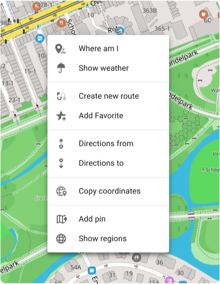
Map Context Menu
For opening it right click anywhere on the map. This menu includes the following actions:
- Where am I
- Show weather
- Create new route
- Add Favorite
- Directions from
- Directions to
- Cope coordinates
- Add pin
- Show regions
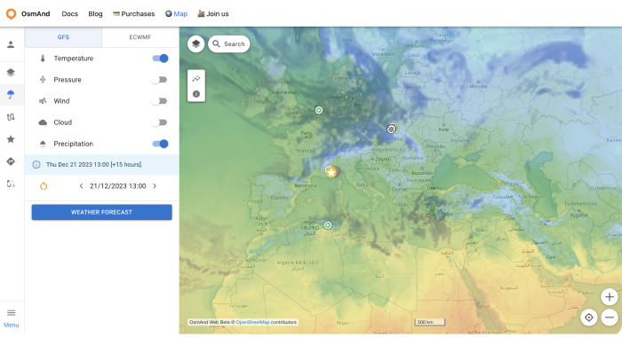
Weather
The Weather plugin is a paid feature of the OsmAnd app. For the web version, Weather is a free feature with such capabilities as:
- Enable weather layers on the map: Temperature, Pressure, Wind, Cloud cover and Precipitation using the menu on the left or right.
- Enable the display of the weather forecast for the day or week (the forecast step is 3 hours).
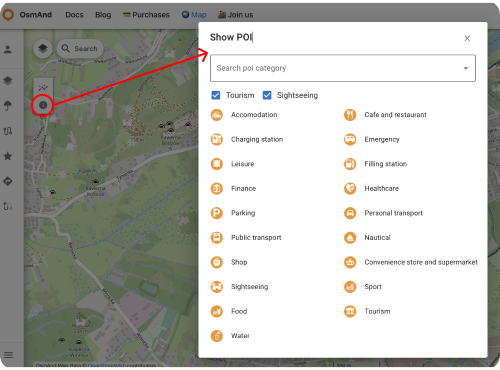
POIs on the Map
To show POIs on the map:
Configure map menu or icon → POI overla... → choose categories
Tracks
It's a paid feature
. At first you need to loggin your OsmAnd Pro: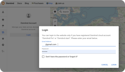
For Track section:
- Show tracks from OsmAnd Cloud.
- Adding tracks on the map (Visible on map folder).
- Looking all tracks info and graph
- Modify tracks and add it to Cloud.
- Download and delete tracks.
- Create new folders or delete it.
- Download folders as OSF or OBF collection.
Visible on the Ьap
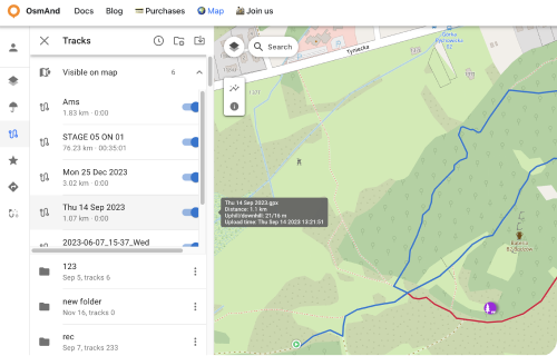
Here there is a list of visible tracks on the map.
Switch on / off tracks for showing or not its on the map.
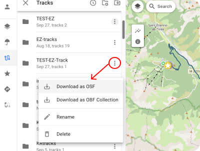
Track folder menu
Click to the Tree points ⋮ button for open Track Folder menu. Here you can Download all tracks from chosen folder as:
Download as OSF.
Download as OBF Collection: You can get OBF map from this data: OBF file or Travel OBF.
You can download offline map OBF (OsmAnd Binary Format) and open it with OsmAnd on device, it's suitable to display large quantity of tracks will be visible on the map.
Also You can import map of tracks as Travel book which will allow you also to select a specific track on the map and use it as normal GPX. Travel book also supports features such as displaying tracks as points, filtering tracks by activity type and filtering waypoints.
Rename chosen folder.
Delete chosen folder.
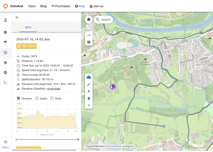
Cloud Tracks
GPX tracks that you have in OsmAnd Cloud will be available for display and editing after login. Only for Pro users
.The following features are available after choosin cloud track:
Information screens:
- Information - displaying track data.
- Elevation - graph of elevation.
- Speed - speed graph.
- Slope - slope graph.
- Settings - list of navigation profiles for the Create route tool.
Action buttons:
- Edit track - adding cloud track to local for editing (Edit locality button on the panel).
- Download GPX - downloads the track to the PC.
- Recalculate Elevation (Satellite) - displays the elevation graph of the selected track.
- Delete Track - deletes the track.
- Close track - close the track.
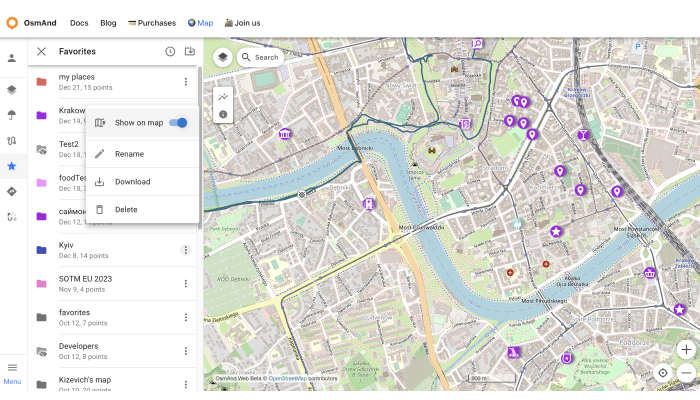
Favorites
After registering an OsmAnd Pro or OsmAnd Start, the user's Favorites are displayed in the Favorites menu.
The following actions are available:
- Show on map - show favorites points from the chosen folder on the map.
- Rename - name and description of favorite folder.
- Download - download the chosen favorite folder.
- Delete - delete the chosen favorite folder.
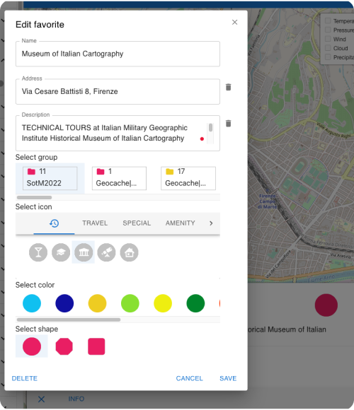
Add / Edit Favorite
To add a new favorite point, right-click on the screen. To start editing, click on the favorite point, the edit menu screen looks the same as the menu in OsmAnd app.
URL Schemes
For easy use of the OsmAnd application you can take advantage of direct links. These are special URLs that allow you to transfer location and contain detailed data about pins and tracks.
These address strings can be copied and transferred using any data transfer medium supported by your device and used in the Android or iOS versions of OsmAnd.
URL with a pin on the map:
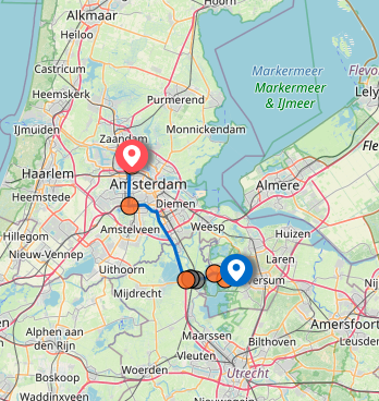
https://osmand.net/map/?pin=52.491143,7.116394#9/52.3924/6.3116
URL without a pin on the map:
https://osmand.net/map/#9/52.3924/6.3116
URL with navigation:
Depending on the specified parameters, URL strings may contain:
- latitude: latitude value as a number.
- longitude: longitude value as a number.
- start-finish: for navigation.
- profile: for navigation.
- zoom: zoom level.
Related Articles
This article was last updated in September 2024