Track Appearance
Overview
Track Appearance is a customizable option in the OsmAnd app that allows you to personalize the visual display of tracks on the map. This feature makes it easier to distinguish between different tracks and understand their characteristics.
- Android
- iOS

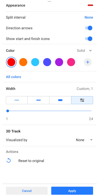
Appearance
In the OsmAnd application, you can apply some settings by changing the appearance of the tracks, to better identify them on the map.
There are three ways to access the Track Appearance menu:
- Go to the My Places menu and tap any available track in the list (Menu → My Places → Tracks), select the Appearance icon in the Track Context menu in the Overview section.
- Tap the needed track on the map and select the Appearance icon in the Overview section.
- Select Appearance from the track recording context menu.
- Go to Menu → Configure map → Tracks → ⋮ → Change appearance for the tracks you have selected to be displayed on the map.
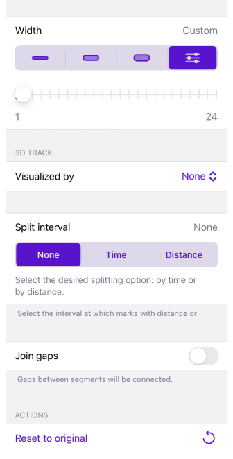
Split Interval
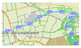
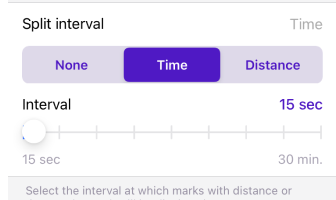
Select the interval at which distance or time stamps are displayed on the track.
Direction Arrows
Select the interval at which distance or time stamps are displayed on the track.
Show Start and Finish Icons
![]()
Allows you to select whether or not to show the start and end icons of track segments.
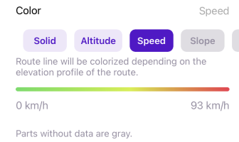
Color
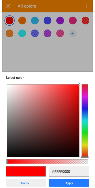
Allows to display the track line in any color and transparency, or select coloring according to the map legend. If necessary data on the track sections are missing, such sections are displayed in gray color.
Color: Solid, Speed and Altitude are free color settings. If Speed and Altitude are not active, it means that the track does not contain this data.
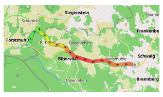
Color: (Maps+ / Pro feature) Slope, Road type, Surface, Smoothness, Winter and ice roads, Surface, Difficulty of horse trails are paid color settings. A detailed description of these settings can be found in the Map screen during navigation page, specifically in the Route line appearance section. You can also select or create custom color schemes to apply to the track appearance.
Width

You can customize the appearance of the track in several menus of the application:
- Track → Appearance.
- Navigation settings → Customize route line.
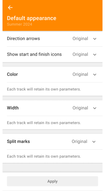
- My Places → Tracks tab → any folder → Default appearance.
With the Width setting you can choose the thickness of the track line based on the width of the road or intersection with other tracks, or for example, if you want to highlight a track on the map by importance.
- Thin, Medium, and Bold are lines whose width is fixed and preset by the OsmAnd application.
- In the Custom setting you can set the required line width with a slider, from 1 to 24.
- In the Tracks tab with the Original setting, different original width parameters can be retained for each track of the selected folder.
- In the Configure Profile the route line can be set to the Map Style width, this is the default width for map specified by the OsmAnd application.
Join Gaps
Gaps in a GPX track can occur during recording, for example. This function (Android: Join segments, iOS: Join gaps) allows you to seamlessly connect all gaps in the chosen GPX track. Segments will be joined with a straight line to form a continuous track.
Reset to Original
Resets all settings to default values.
3D Track

The 3D Track feature provides a three-dimensional representation of tracks by adding elevation information to standard 2D tracks. This creates a 3D effect with depth, allowing you to better visualize the track in relation to the terrain.
- Android
- iOS
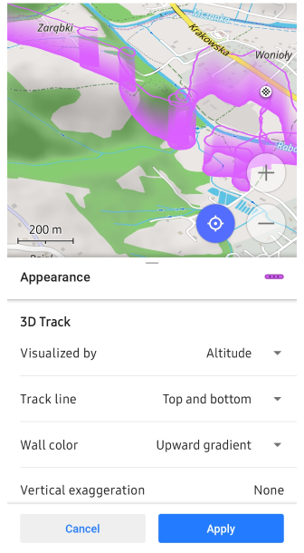
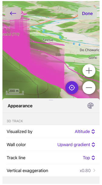
Wall height. You can visualize 3D track by altitude but also by other available data inside the track or by fixed altitude.
- Visualized by: Altitude, Speed, Fixed Height. 3D Sensor data: Heart Rate, Bicycle Cadence, Bicycle Power, Temperature, Bicycle Speed.
- Vertical exaggeration. You can scale 3D data to get more prominent visualization.
- Wall height. If Visualized by Fixed Height, set the fixed height for the 3D track by defining its elevation on the map in the range of None to 2000 m.
- You can combine with 3D Relief. If source of 3D data is not alitidue, then 3D data will be represented as the sum from relief altitude and the data for example speed or heart rate data.
Wall color. You can select the wall color to the same visualization as 3D data or you can choose something else to get another visible data dimension.
- Options include: None, Solid, Downward Gradient, Upward Gradient, nbsp;Altitude, Slope, Speed.
Track line. You can add a line to the top or bottom of 3D track for clearer visualization. Please note that you can configure color of the track line as well.
- Options include: Top, Bottom, Top and bottom.
The Android version of the app requires the map rendering engine Version 2 (OpenGl) to be enabled to use 3D track visualization.
Use Cases
3D track is useful for sports like paragliding where you can visualize your flight. Though visualization track in 3D could be useful for visual analysis as Wall height and Wall color provide a lot of visual information.
Visualize by Speed with 3D. One of the example is to use 3D track with Speed visualizations, so you can see what particular sections on the map caused slow down and speed up. With Wall color indication by Slope it's also possible to get an understanding how high hills impact the speed.
Visualize by Heart sensor + 3D Relief. Another interesting use case to visualize tracks by heart sensor data and get direct analysis on the map what was going on. With 3D relief enabled altitude will sum up with heart rate and could be useful in some scenarios. Please note that there are 2 Vertical exaggeration parameters and they work separately for 3D relief and for 3D track.
Visualize Track height + Slope color line on flat earth. If you visualize tracks by altitude then it's better to do on flat earth cause GPS errors of recorded altitude could hide track underground. In this use case you can visualize slope changes separately on the track line and wall color use for altitude.
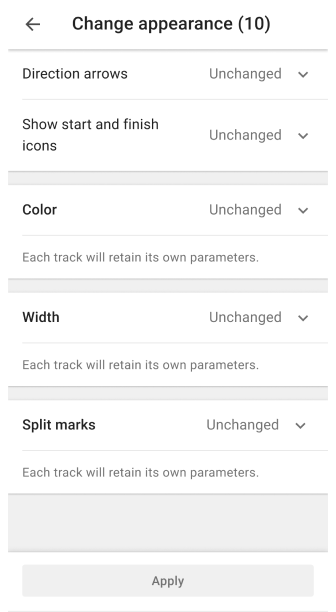
Change Appearance of Multiple Tracks
The display of tracks can be changed one by one and in groups selected from the My Places menu in the Tracks tab. This tab automatically displays all tracks ever recorded, created, or imported. They are organized by folder or displayed as a list below them.
You can change the default appearance of all tracks in the folder by using the Change Default Appearance option. Though if track already has specific parameters to be displayed they won't be applied, in that case you can reset track appearance first to Original via Change Appearance.
With Select, you can change the appearance of certain tracks in the selected folder or in the whole list of the Tracks tab. To go to Change Appearance, select the three-dot menu in the upper right corner of the Tracks tab screen and tap Select. Then tap the three-dot menu at the top of the screen and select Change Appearance.
- Direction arrows. Adds directional indicators to a track line in the form of arrows along that track.
- States: Unchanged, Original, On, Off.
- Show start and finish icons. Adds start and end point indicators to the track line.
- States: Unchanged, Original, On, Off.
- Color. Allows you to select the appropriate type of track coloring.
- Width. Allows you to select a preset or manually configured track line width.
- Split interval. Select the interval at which distance or time marks on the track will be displayed.
- States: Unchanged, Original, Select: Time or Distance.
Related Articles
This article was last updated in August 2024